Waterfalls of Western North Carolina
Relocating to Western North Carolina mountains? Check this Out! Great Carolina Property

Western North Carolina Waterfalls
Hayesville Area/ Clay County
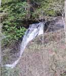
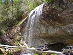
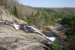
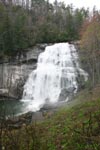
Leatherwood Falls at Firescreek
Recreation Area | s in Clay County North Carolina. A beautiful,
perhaps less dramatic, example of nature and gravity. Part of the
Nantahala National Forest.
The 25-foot falls is visible from the picnic area or along a barrier-free,
paved trail alongside the creek. The ice-cold water of Fires Creek
provides an invigorating swim for hearty souls, particularly under
the bridge where it is 6 or 7 feet deep. Leatherwood is a common family
name in the area, and generations of local children have frolicked
in the creek or fished for trout along its banks.
Franklin Area/ Macon County
In a beautiful part of the Nantahala
National Forest near Standing
Indian Campground | s this little
jewel of a waterfall called Big Laurel Falls. A short .6
mile hike that follows the path of an old logging railroad, the trail
meanders along a raging noisy Big Laurel Branch creek with lots of
big boulders.
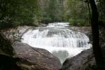
Bull Cove
Bull Cove Falls is about 40 feet high and on
the same trail as High Falls. Bull Cove is a nice falls and well worth
seeing. If you're heading up to High Falls, rest up here - you'll
need it.
From Lake Toxaway, take 64 west through Highlands
and towards Franklin. Near Franklin, get on 441 south and drive 20
miles to Clayton, GA. Turn right on Hwy 76 west, drive 8 miles and
turn right on Persimmon Rd. Just over 4 miles up this road, take a
left on Tallulah River Road - also marked FR70. This narrow road starts
out paved, but turns to gravel and generally follows the Tallulah
River. It's a very scenic drive, but it's an additional 7.5 miles
to the Beech Creek Trail parking area on the left. This road crosses
back into NC closer to the parking area. It took us over 2 hours drive
time from Lake Toxaway to get to the parking area.
The blue blazed trail begins across
the road to the right coming out of the parking area. It heads steeply
straight up hill, then begins to switchback as it continues up the hill.
From the crest, the trail then descends and crosses Beech Creek. There's
a log to cross on - you may have to get your feet wet otherwise. The
trail continues on and connects with an old road - bear left here. In
another 1/2 mile (about 1 mile total from the parking area) cross Bull
Cove Creek and take the trail to the right that heads up creek to the
falls. Bull Cove Falls is about 40' high in 2 levels.
Directions:
From Clayton, Georgia take US 76
7.9 miles to Persimmon Rd, turn right. Drive 4.1 miles to Tallulah River
Rd. (FR 70, which changes to FR 56 at the NC state line) turn left.
Drive 7.6 miles to a parking area on left. Trail begins on opposite
side of the road ( FR 378). Trail is 1 mile long.
High Falls
High Falls is over 150 feet high. See Bull
Falls to get to main trail
If you are heading up to High Falls, come back
out to the main trail and turn right. The hike up to the falls is
a steady uphill trek - another 1.5 miles. You'll soon cross Beech
Creek again and be on the left side. Since it was winter, we had a
great view of the creek which was mostly below us. The creek is almost
one continuous cascade. Closer to the falls, the trail begins to switchback
up the mountain. At the 1st turn to the left, a small trail continues
straight, take the main trail to the left. At the next turn to the
left, a side trail marked with a 'High Falls' sign nailed to a tree
leads down hill to the creek and the base of the falls. High Falls
is a beautiful 150' falls cascading over a rock face.
Directions:
Same as Bull Cove Falls: From Clayton, Georgia
take US 76 7.9 miles to Persimmon Rd, turn right. Drive 4.1 miles
to Tallulah River Rd. (FR 70, which changes to FR 56 at the NC state
line) turn left. Drive 7.6 miles to a parking area on left. Trail
begins on opposite side of the road ( FR 378). Trail is 2.5 miles
long
County: Macon Height: 80 feet Water Source:
Cullasaja River Mountains: Southern Appalachian Mountains Park: Nantahala
National Forest Owner: Federal Trail Length (one-way): 0.1 mile Trail
Difficulty (scale: 0 easy-10 very difficult): 5Beauty Rating (scale:
10 highest): 8 Wheelchair Accessible: Yes
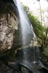
Facts: Here the Cullasaja River projects over
an overhanging cliff, allowing people to walk behind the waterfall
without getting wet, hence the name Dry Falls. If the river is up,
you may question the appropriateness of the name; the constant spray
will soon have you drenched.
>
Cullasaja Falls is a beautiful falls flowing
out of the Cullasaja River Mountains in the Southern Appalachian Mountains
and located in the Nantahala National Forest along a very dangerous
stretch of Hwy 64. The 250' falls and cascades is viewable from the
road, but there's only a small pull off area suitable for 2-3 vehicles.
The safest way to approach is from the Franklin side, west of the
falls. From the intersection of Hwy 441 and 64 east, the falls is
about 7.7 miles east on 64. If you are coming from Highlands, the
falls is 5.5 miles past Dry Falls. You might do better passing the
falls and turning around a little ways down the road. Pull completely
off the road! You'll have the view of the falls in the above shot
from the pull off.
The gorge leading to the falls is part of the
trail for DeSoto's 1540 expedition in search of gold. The name, Cullasaja,
comes from a Cherokee word meaning "honey locust place."
Beauty Rating (scale: 10 highest): 9 Wheelchair
Accessible: Yes
A .6 mile drive up the road
from Laural Falls you'll hear this
waterfall before the turn out. The trail here is less than 1/4 mile
both ways and really easy, making this a walk for most anyone. With
multible switchbacks making the gentle decent, the trail splits about
half way to the falls allowing you to go above the main chute or below.
The left trail takes you above the main falls but allows you to see
a mulitible cascade of small drops. The right trail takes you to the
base. Lots of storm damage has placed many logs in this falls and
has damage the folage along the walk, but the easy walk makes it worth
including this one on your list.
Rufus Morgan Falls
A nice walk through the forest.
The trail is about 1/2 a mile, easy to follow, and easy to moderate
in difficulty. To see the falls through the leaves may be difficult,
winter or early spring is best to view the falls.
Hwy 64 out of Franklin for about
5 miles and turned right on Old Murphy Rd, then turned left on SR1310
less than 1/4 mile down - it's just past the gas station. After 6.3
miles, we turned left on FR388 and followed it up for 2 miles to the
obvious parking area on the right.
Upper Buck Creek Falls
County: Macon Height: 100 feet Water Source:
Buck Creek Mountains: Glenville Park: Nantahala National Forest, Highlands
Ranger District Owner: State Trail Length (one-way): .25 miles Trail
Difficulty (scale: 0 easy-10 very difficult): 5-10 Beauty Rating (scale:
10 highest): 4 Wheelchair Accessible: No
Facts: Upper Buck Creek Falls is a beautiful,
cascading stream that would be popular were it not for its inaccessibility.
Should you decide to visit this falls, you are sure to be alone.
Highlands Area/Jackson County
Bridal Veil Falls is approximately
60 ft in height and a tributary of the Cullasaja River. Bridal Veil
is a popular falls because of it's easy access. It's right next to
the road. you use to be able to drive under it but not anymore. A
huge bolder broke off the falls so now it has slid into the roadway
and is no longer passable. Bridal Veil is located in Macon County
about 2.5 miles northwest of Highlands on Hwy 64 and is on a tributary
of the Cullasaja River. There's a forest service sign just before
the falls, which are on the right side of the road.
Less than a mile west of Bridal Veil is Dry
Falls which is also handicap accessible. It will be on the left and
if you miss the 1st turn into the parking area, you can take the next
one. Dry Falls is on the Cullasaja River and the walk from the parking
area is a very short one.
You can walk underneath these
80 ft falls The path is maybe about 30 ft below the top of the falls
- it seemed like it was a longer way down to the river below than to
the top and you may be able to see a rainbow if the sun is in the right
position. The spray from the falls may get you when you walk underneath.
Very pretty site, but rather touristy.
A steep, rough 1-mile trail leads
to the falls. three large waterfalls make up Glen Falls the upper is
70 ft, then a 60 ft drop, then a 15 footer . The trail is 3/4 mile and
not bad. The trail leads you to all 3 sections.
Heading west on Hwy 64 in Highlands,
take a left on Hwy 106, go about 1.7 miles and look for the sign to
Glen Falls Scenic area on the left. The gravel road to the Falls (SR
1618) veers off immediately to the right after you take the left, so
go slow. The road dead ends into the parking area.
Grassy Creek Falls
Many visitors to the DuPont State
Forest have visited Wintergreen Falls on the Grassy Creek. However,
most are not aware of another water slide on same stream, named Grassy
Creek Falls. These falls, which lie on the newly acquired property,
are nearly 2 miles downstream of Wintergreen Falls, not far from High
Falls and the mouth of Grassy Creek.
On some topographical maps, the
Grassy Creek Falls are shown to be on Little Mill Creek rather than
on Grassy Creek. This is thought to have occurred due to an accidental
switching of creek names by map makers.
Located in Jackson County: Grassy
Creek Falls is 100 feet high flowing out of the Grassy Creek Mountains
of the Southern Appalachian Mountains Park There is one-way trail
but it's a private so this one you'll have to see by the roadside.
Trail Beauty Rating : 5 Wheelchair
Accessible: Yes
Kalakaleskies: Lake Sequoyah Falls
Located off US 64/28 west, 2.5 miles
northwest of Highlands on the Cullasaja River. The Sequoyah Dam is at
the head of the falls. There are 18 small falls within a quarter mile
paralleling US 64/28.
Picklesimer Rock House falls
Picklesimer Rock House falls is
another lesser known falls that is well worth visiting. The half mile
trail is an easy hike and the reward is a 40' free falling waterfall
in front of a deeply recessed rock house.
From the intersection of Hwy's 64
and 28 in Highlands, drive 5.8 miles south on Hwy 28 and take a sharp
right on SR1618 at a sign for the Blue Valley Campground. This road
becomes gravel and FR79. Drive 4.2 miles down this well maintained road
through the Nantahala National Forest and park at an old logging road
heading up to the right. It's gated, but the gate is maybe 50-75 yards
up. Hike for less than 1/2 mile to a wildlife clearing. Pass through
the clearing to a creek and take the faint trail to the right up the
creek a short distance to the falls. Steep hills flank both sides of
the falls and the rock house is undercut enough to provide shelter during
a rain storm.
Satulah Falls
A high, narrow waterfall visible
from the overlook, 2.5 miles south of Highlands on US 28.
Franklin Area
Secret Falls
This little known waterfall in the Nantahala
National Forest is listed in the Adams' book, but it doesn't give
directions because part of the trail may pass through private property.
The trail isn't marked with no trespassing signs, just the land to
the left of the trail.
Coming from Lake Toxaway, head
out Hwy 64 west into Highlands. At the main stop light in town, 64 turns
right, Hwy 28 goes straight, you turn left on Main Street. After it
leaves town in a couple of blocks, it's called Horse Cove Rd. Take this
curvy road down hill for about 4 miles and turn right on Walking Stick
Rd (SR1608). At 0.6 miles down this road on the right is Walking Stick
Falls. It's right next to the road, but on private property being developed
with signs saying 'no poor people allowed', so we slowed down and looked,
but didn't stop. Not a good photo op anyway. Parking for the trail to
Secret Falls is 2.9 miles down Walking Stick, right where FR4567 turns
right. This is Game lands and that road is open during hunting season,
but park before the gate. The trail is to the left of the gate and heads
slightly down hill. Not to far down the trail were the 'land for sale'
and 'no trespassing signs' to the left and Game lands signs to the right.
About seven minutes down the trail, cross a creek . A little further
cross another creek on a fallen log, headed up hill, and in 3 more minutes
take a trail to the left and down hill towards the top of the falls.
So you've got about a 15 minute easy hike and by now you should have
penciled this 50' falls in as a 'must see'.
A small side trail heads to the
top of the falls and comes out on a very safe flat rock area with a
great view of the creek below. Just up Big Creek are 2 smaller drops
and a shallow pool.
A 30-foot falls spilling into a pool of water.
Off NC 107, 4.1 miles south of Cashiers. Park in the pull-off on the
left and take the short, easy trail to the base.
To ge to this falls, head west on Hwy 64 from Lake Toxaway into Cashiers
and take a left on 107. The 25' Silver Run Falls is a little over
4 miles down on the left and we stopped here before crossing into
SC. Lots of ice, very cool, and worth a return trip in warmer weather.
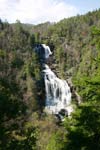
At 411 feet, the highest falls east
of the Rockies. From Cashiers, take NC 107 south 10 miles to the NC/SC
line, then travel another mile and take the first paved road to the
left. Fee site.
Graham County
Big Falls
County: Graham Height: Small multilevel
cascade Water Source: Snowbird Creek Mountains: Snowbird Mountains Park:
Nantahala National Forest Owner: Federal Trail Length (one-way): 3.9
miles Trail Difficulty (Scale: 0 easy-10 very difficult): 3 Beauty Rating
(Scale: 10 highest): 6 Wheelchair Accessible: No
Facts: Even though the falls is named "Big Falls," the falls
is a multilevel cascade which is definitely not "big." A steep
side trail leads to the base of the cascade, where silky willow shrubs
grow near a flat, rocky area.
Middle Falls
County: Graham Height: 20 feet Water
Source: Snowbird Creek Mountains: Snowbird Mountains Park: Nantahala
National Forest Owner: Federal Trail Length (one-way): 5.1 miles Trail
Difficulty (Scale: 0 easy-10 very difficult): 3-7 Beauty Rating (Scale:
10 highest): 7 Wheelchair Accessible: No
Facts: The cardinal flowers blooming in August around Middle Falls make
that month an excellent time to visit. Of the four falls in the Snowbird
Creek basin, Middle Falls is considered the best for photographing.
Upper Falls
County: Graham Height: Small sliding
cascade Water Source: Snowbird Creek Mountains: Snowbird Mountains Park:
Nantahala National Forest Owner: Federal Trail Length (one-way): 6.3
miles Trail Difficulty (Scale: 0 easy-10 very difficult): 3-7 Beauty
Rating (Scale: 10 highest): 4 Wheelchair Accessible: No
Facts: Upper Falls is small and hidden from view by overgrown vegetation.
Most of the tail to Upper Falls is along an old narrow-gauge railroad
grade. In the 1930s, there was extensive timber logging in the Snowbird
Creek basin. The railway was used to haul out the logs. After the Forest
Service purchased the land in 1943, the tracks were removed
Sassafras Falls
County: Graham Height: 50 feet Water
Source: Sassafras Creek Mountains: Snowbird Mountains Park: Nantahala
National Forest Owner: Federal Trail Length (one-way): 3.5 miles Trail
Difficulty (Scale: 0 easy-10 very difficult): 3-6 Beauty Rating (Scale:
10 highest): 5 Wheelchair Accessible: No
Facts: The basin containing Sassafras Falls was used by the Cherokee
Indians as a hideout during the Removal of 1838. Descendants of those
Indians now live nearby in the Little Snowbird community.
Haywood County
Mouse Creek Falls
County: Haywood Height: 35 feet
Water Source: Mouse Creek Mountains: Blue Ridge Mountains Park: Great
Smoky Mountains National Forest Owner: Federal Trail Length (one-way):
2 miles Trail Difficulty (scale: 0 easy-10 very difficult): 3 Beauty
Rating (scale: 10 highest): 6 Wheelchair Accessible: No
Facts: This waterfalls is accessible to campers at Big Creek Campground.
Yellowstone Falls
County: Haywood Height: 125 feet
Water Source: Yellowstone Prong Mountains: Blue Ridge Mountains Park:
Pisgah National Forest Owner: Federal Trail Length (one-way): 0.5 miles
Trail Difficulty (scale: 0 easy-10 very difficult): 5 Beauty Rating
(scale: 10 highest): 4 Wheelchair Accessible: No
Facts: The name for the falls comes from the yellow lichens and minerals
in the valley rocks
Transylvania County
Pisgah National Forest is home to
numerous waterfalls. This section focuses on the Pisgah Ranger District
of the forest, mostly north of Brevard. I've hiked here on several occasions
and have only scratched the surface of things to see. It's a great place
for families with kids to begin exploring waterfalls. Falls here include
Looking Glass, Moore Cove, Cove Creek, Daniel Ridge, Courthouse, Chestnut,
Flat Laurel Creek, Grogan Creek, Cedar Rock, Slick Rock, the falls in
the Henry Branch area, Sam Branch, Wash Hollow, Log Hollow and Cathy's
Creek Falls.
The land of Waterfalls
Was bestowed on Transylvania County
in 1912 for good reason; Transylvania contains more waterfalls than any
other county in the state. Waterfalls are plentiful in Transylvania County
primarily because of the topography and geology of the region. The county
lies between the high points of the Blue Ridge Mountains and the Piedmont
regions of North and South Carolina. Because of the location there is
a significant change in elevation throughout the county. Another very
important aspect of Transylvania's immense abundance of waterfalls is
the amount of rainfall. Transylvania County has the highest average rainfall
east of the Pacific Northwest. Brevard averages nearly 70 inches annually
and Lake Toxaway, in the western part of the county, averages 80 inches.
Though Transylvania's waterfalls are at present visited by tourists, earlier
in history they were sites for industries. Settlers used many of the falls
in the region for water-powered grist mills, hence came such names as
Mill Shoals or Mill Falls. Not all early industries located around waterfalls
were legal.
The production of moonshine,' the
illegal manufacturing of homemade liquor, was easily concealed near isolated
waterfalls. This became a booming business for bootleggers. Today Transylvania's
waterfalls brings. tourists from all over.
Bear Wallow Falls
-U.S. 64 Southwest to Whitewater Road, turn
left four and one-half miles. Bear Wallow Creek is probably the most
rugged stream in Transylvania County. From its origin near Oakland,
it is a continuous series of falls and cascades until it joins Toxaway
River near the head of Lake Jocassee. To reach the upper falls follow
U.S. 64 from Rosman for 13 1/2 miles or one and one-half miles west
of Toxaway River Bridge.
Cathey's Creek Falls
Cathey's Creek Falls is beautiful,
secluded, and easily accessible but hard to find. Falls are down a small
unmarked trail but worth the 300 yard walk. To find the falls go approximately
three and one-half miles from Brevard on U.S. 64 west.to SR1401turn
right(north) then in 50' turn left onto State Road 1338, which turns
into FS471 as you enter Pisgah National Forest. When the pavement ends,
go 2.5 miles past the water treatment plant. Look for power lines crossing
the road and you'll see a single car pull out on your right.
Cedar Rock Creek Falls
Near Cedar Rock Mountain in Pisgah
National Forest. State Road 1338, right from U.S. 64 at Cathey's Creek
and on right from road a short distance from Cathey's Creek Road. two
falls on creek.
Courthouse Falls
Hike down short trail at last bridge
on Forest Service Road l 40 Courthouse Creek Road) off NC. 215 above
Balsam Grove.
County: Transylvania Height: 45
feet Water Source: Courthouse Creek Mountains: Devil's Courthouse Mountain
Park: Pisgah National Forest Owner: Federal Trail Length (one-way):
0.3 miles Trail Difficulty (scale: 0 easy-10 very difficult): 5 Beauty
Rating (scale: 10 highest): 6 Wheelchair Accessible: No
Facts: The waterfalls and mountain derive their names from Indian lore.
The Cherokees believed a cave in the mountain was the courtroom of the
giant Judaculla.
Connestee Falls
Two falls are at the same location, Connestee
and Batson creeks, and can be viewed from many places from well-kept
trail to the toot of these waterfalls. Each tall is about 110 feet
high. About 100 yards from U.S. 276, 10 miles south of Brevard. CLOSED
TO THE GENERAL PUBLIC.
County: Transylvania Height: 110
feet Water Source: Carson Creek Mountains: Blue Ridge Mountains Park:
Connestee Falls Owner: Private Trail Length (one-way): Few feet Trail
Difficulty (scale: 0 easy-10 very difficult): -- Beauty Rating (scale:
10 highest): 7 Wheelchair Accessible: No
Facts: According to Indian lore, the Princess Connestee leapt to her
death over the falls after her English husband returned to his people.
Dr. F. A. Miles named these falls for the Indian princess in 1882.
Cove Creek Falls
A 30 foot falls off Caney Bottom Creek Trail
above the Cove Creek Campground. Park at the gate to campgrounds
approximately two miles above Pisgah Fish Hatchery on Forest Service
Road 475.
Dismal Falls
Bushwhack one-and one-half miles up treacherous,
undeveloped path to Diamond Creek. Access is on N. C. 281 near where
it climbs away from West Fork French Broad River.
Diamond Creek Falls
Diamond Creek flows into North
Fork of the French Broad River near Rosman. Between the river's North
Fork and West Fork near State Road 1322.
Drift Falls
County: Transylvania Height: 80
feet Water Source: Horse pasture River Mountains: Blue Ridge Mountains
Park: Nantahala National Forest Owner: Federal Trail Length (one-way):
0.1 miles Trail Difficulty (scale: 0 easy-10 very difficult): 7 Beauty
Rating (scale: 10 highest): 7 Wheelchair Accessible: No
Facts: Drift Falls is known also as Bust Your Butt Falls or Driftwood
Falls.
Flat Creek Falls ( also called Lovers Falls )
In Quebec community to right of state Road
1313. Other falls off State Road 1147, South of U.S. 64.
Frozen Creek Shoals
Near State Road 1139 in the Frozen Creek
- Old Toxaway areas requiring only a very short hike to bottom of
the Falls.
Glen Cannon Falls
One of these twin falls can be seen from
the Glen Cannon Golf course. The second green is just in front of
the lower falls, and a short hike is required to the top falls.
High Falls
On the South Fork of Mills River in Pisgah
National Forest. Several other falls are on this fork between the
Pink Beds and the Henderson County line, which requires a two mile
hike from Wolfe Ford Road (FS 476).
John's Jump Falls
County: Transylvania Height:
25 feet Water Source: Mill Creek Mountains: Southern Appalachian Mountains
Park: Nantahala National Forest Owner: Federal Trail Length (one-way):
0.1 miles Trail Difficulty (scale: 0 easy-10 very difficult): 6 Beauty
Rating (scale: 10 highest): 4 Wheelchair Accessible: No
Facts: This waterfall was named in the early 1920s for John Hinkle
who jumped down a large rock to get to the base of the falls
Kiasee Falls
In a hidden cove under the Pisgah Ledge near
Pinhook Gap Road 1369. In general area of Courthouse Falls.
Kathey Falls
On Bearwallow Creek about one
mile from Toxaway Falls Road or three-fourths of a mile from U.S.
64. Kathey is probably the most visited of the many falls on this
tributary of the Toxaway River.
Lake Toxaway Falls
U.S. 84 crosses the top of the falls, 123
feet high, 20 miles southwest of Brevard.The waterfalls are just
below Toxaway Falls dam, named Toxaway (Red Bird) by the Cherokee
Indians.
Laughing Falls
One mile off U.S. 280 on Turkey
Creek. Near State Road 1360 in Pisgah National Forest.
Laurel Falls
County: Transylvania Height: 400 feet Water
Source: Corbin Creek Mountains: Southern Appalachian Mountains Park:
Nantahala National Forest Owner: Federal Trail Length (one-way):
0.8 miles Trail Difficulty (scale: 0 easy-10 very difficult): 8
Beauty Rating (scale: 10 highest): 3 Wheelchair Accessible: No
Facts: Laurel Falls is also known
as Corbin Creek Falls.
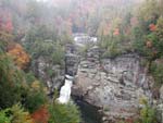
Linville Falls is located on the Blue Ridge
Parkway. Trails lead to views of both the upper and lower falls. Forests
offer virgin hemlock mixed with other familiar trees such as white
pine, oaks, hickory, and birch. A colorful and varied display of wildflowers
decorates the trails in the spring. Red and golden leaves in fall
beautifully contrast with the soothing green of hemlocks.
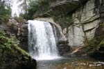
Looking Glass Falls is one of the
most scenic and best known falls in the Eastern United States. This
picturesque unbroken rush of water is 30 feet wide and over 60 feet
high The fall is named after the immense dome Looking Glass Rock. A
few miles past the entrance to Pisgah National Forest, the 65' fall
is right beside the road for Roadside viewing and assessiable to the
handicapped. Considered a "10" on the beauty scale this is
one you won't want to miss.When the falls become frozen, the surface
of the cliffs reflects sunlight to resemble a looking glass.
Mill Shoals Falls
Adjacent to Owens Gap Road near Jackson County
line.Two other falls can be visited in same area - Dismal Falls and
Still House Falls left of State Road 1308.
Moore Cove Falls
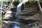
A 50 foot falls at the end of
a popular 0.7 mile trail. Parking is along U.S. 276 about 6-1-2 miles
above the Ranger Station.
County: Transylvania Height: 50
feet Water Source: Moore Creek Mountains: Blue Ridge Mountains Park:
Pisgah National Forest Owner: Federal Trail Length (one-way): 0.7 miles
Trail Difficulty (scale: 0 easy-10 very difficult): 5 Beauty Rating
(scale: 10 highest): 7 Wheelchair Accessible: No
Facts: Moore Cove Falls has a large ledge which creates an overhang
with a walkway behind the 50-foot falls.
Follow directions to Looking Glass
falls then Drive past looking Glass Falls and follow road until
you come to a stone bridge, park on the right before
the bridge, entrance to the trail is on the right
at beginning of bridge, you'll follow the trail for
approximately 3/4 of a mile to Moores Cove Falls
bring a picnic it's a beautiful spot!!!!! There is
a small waterfall just to the right about 250 feet
coming from Moores Cove Falls...
Trail Length .75 miles Difficulty adults-4 children-8
be warned you will go through some mud and over a few
logs and downed trees but path is 95% clear.
MT Toxaway Falls
Just over the Jackson County line.
Probably the highest falls in the area. Turn right from U.S. 64 on road
to Mt. Toxaway Lookout Tower. Lake Toxaway, Rosman Research Station
and various other places of interest can be seen from the top of the
mountain.
Pounding, Mill Falls
On Middle Fork of French Broad River near Eastatoe
Gap. Can be seen from U.S. 178 or by turning on road to lakes.
Rainbow Falls
Near Whitewater Falls Road. Waterfalls
on Horse pasture River one-fourth mile from N. C. 281. Drift Falls are
passed before reaching the 200-foot-high Rainbow Falls.
Raven Cliff Falls
Drops 600 feet in the space of
about a half mile. Two miles on right of U.S. 276 before reaching Caesar's
Head. A steep path of about 60 degrees leads to the bottom of the falls.
Slick Rock Falls
On Head Water Road (FS 47SB) between
the Pisgah Fish Hatchery and the Pink Beds. This Forest Service Road
offers a nice drive to U.S. 276 with excellent views of John Rock and
Looking Glass Rock.
Located approximately 1.5 miles from the
Pisagh National Forest Fish Hatchery
Follow the directions for Looking Glass Falls
At the fork bear left instead of right onto fr475
follow that past the hatchery to fire road 475b
Slick Rock will be about 1.3 miles on the right
there will be a small parking area on right more like a
pull-off, park here a small path of about 100 feet is to the
lower right of the main trail do not go up the steps to
get to the base of the falls!!!!!
Slippery Rock gets it's name from the moss
that grows on the rocks, it is not uncommon to see
the remnants of a deer at the base of the falls
as they loose footing and are swept over the top of the falls.
On this day we did not see any, but most of our shots
were from a deer bed area to the right of the falls...
Stairstep Falls
Near the headwaters of Lake Jocassee
on Horse pasture River. Rough terrain, but falls can be reached by a
hike down the river from Whitewater Road (N. C. 281). Several other
fails can be seen on way to Stairstep Falls.
StillHouse Falls
A few of the water falls in the area have dry
spaces between the water and the back wall. One of these, Stillhouse
Falls, was named by the Boy Scouts, who found a liquor still behind
the falls. Bushwhack from N.C.1306 or N.C. 1375.
Twin Falls
County: Transylvania Height: 100
feet (each) Water Source: Henry Branch and tributary Mountains: Blue
Ridge Mountains Park: Pisgah National Forest Owner: Federal Trail Length
(one-way): 2.2 miles Trail Difficulty (scale: 0 easy-10 very difficult):
7 Beauty Rating (scale: 10 highest): 8 Wheelchair Accessible: No
Facts: Twin Falls consists of two 100-foot waterfalls, located on different
water sources.
Turtle back falls
A beautiful powerful falls on the trail to
Rainbow Falls. More coming soon!
Whitewater Falls
Turn south from U.S. 64 onto N. C. 281 near
Sapphire. Parking area is near the South Carolina line.
White Owl Falls
On head waters of Thompson River on Whitewater
Falls Road 1149 in the Bohaynee area. Between Rainbow and Whitewater
Falls.
Windy Falls
Like many waterfalls, Windy has been known
by several names. On the Horse pasture River between Rainbow and Stairstep
Falls.
Wintergreen Falls
On the Toxaway River just above
the entrance to Bear Wallow Creek. One of the most beautiful waterfalls-
in the area. Plans should be made to see Bear Wallow Falls on the same
hike. To see several falls, go down Bear Wallow then turn up Toxaway
to Wintergreen.