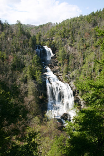
Fall size:411'
Beauty Scale:
(1-worth seeing-10 awesome)10
Directions:
From Cashiers, North Carolina
Drive south on NC 107 for 9.3
miles. Shortly after crossing the State line, turn left at the sign
for Whitewater Falls. Continue 2.3 miles to the intersection with SC
130, which becomes NC 281 at the North Carolina State line. Just beyond
this point is a sign for the entrance to Whitewater Falls.
From Brevard:
Drive west on U.S. 64. At Sapphire,
turn left on NC 281 and go south to the Whitewater Falls entrance
From Asheville:
Take 240-West to I26-West. Go
to the Asheville Airport/Brevard Exit (exit 9) and take a right onto
U.S. 64. Drive to Brevard and follow above directions.
Facilities:
Picnic tables, restrooms,wheelchair accessible,
no camping
Fees:
$2 for vehicles with seven passengers or less;
$1 per person for more than seven people traveling together in a vehicle.
Annual pass available for $15; One-day or season permits are also
valid at Whiteside Mountain and at Dry Falls.
Closest town:
Cashiers North Carolina
For more information:
Highland Ranger District
2010 Flat Mountain Rd.
Highlands, NC 28741
(828) 526-3765
Whitewater Falls
 ...
...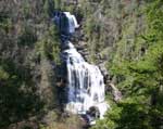
Whitewater Falls, also called Upper Falls,
plunges 411 feet, in two distinct steps, making it one of the highest
falls east of the Rockies. When it comes to the tallest overall drop,
some have claimed
that Upper Whitewater Falls has the tallest drop east of the Rockies.
However, it is one upped by another fall in North Carolina, Windy
Falls,
which is
a 1/4 mile long series of cascades, dropping 729 feet.
Whitewater Fallswaterfall is designated a North Carolina Natural Heritage Area
and is located in the southwest corner of the county on the border
of Jackson and Transylvania counties.
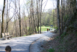
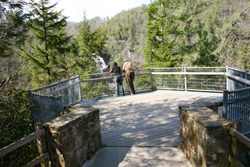
It's an easy walk on the paved trail to the
upper overlook for an excellent view of the Falls. The walkway begins
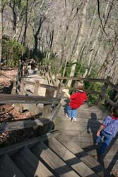
at the end of the parking lot and is accessible to wheelchairs. A
lower overlook is located at the bottom of 154 wooden steps. The best
views of the falls are from the two overlooks. More energetic hikers
can continue down the half-mile round trip spur trail that drops 600
feet in elevation to the Whitewater River and Foothills Trail. With
the exception of the two overlooks near the top, no other views of
the falls are offered.
The Foothills Trail stretches along the Blue
Ridge Cliffs in North Carolina and South Carolina for 85 miles. After
descending the spur trail, hikers may head east on the Foothills Trail
to South Carolina's Lower Whitewater Falls that drops another 400
feet. Because of the cliff's difficult access and rugged terrain,
much of the area receives few visitors and has remained wild and undeveloped
over the years. The Highlands Ranger district of the Nantahala National
Forest manages a 4.5-mile segment of the Foothills Trail from the
NC-SC State line east of Whitewater Falls to the NC-SC State line,
west of the falls.
Caution :
For
those who wish to venture out near the brink of the falls, keep in
mind that Whitewater Falls claims more lives than any other in the
state. Some people who have ventured off the trail to try for better
views, tragically, fell to their deaths or suffered serious injuries
at Whitewater Falls. Please stay on the trails. Use good judgment
and caution while near all water falls at all times.