Wildlife:At an elevation of 3,520 feet, the overlook affords
opportunities to watch from above the aerial aerobics of a variety of
summer birds such as the broad-winged and red-tailed hawk (Buteo platypterus
and B. jamaicensis), cedar waxwing (Bombycilla cedrorum), great crested
flycatcher (Myiarchus crinitus), American goldfinch (Spinus tristis),
indigo bunting (Passerina cyanea), pileated woodpecker (Dryocopus pileatus),
downy woodpecker, scarlet tanager, and numerous warblers.
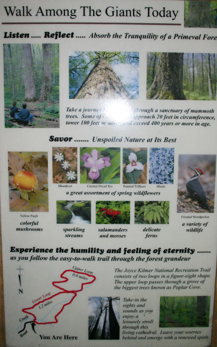
Flora for Fauna: A variety of violets, trilliums , solomon's seal , galax , crested dwarf
iris , jack-in-the-pulpit , and carpets of ferns.
In addition to the mighty yellow-poplar
and Eastern hemlock, the forest has red oak , basswood , red maple , American
beech , yellow birch , Carolina silverbell, dogwood , and witch-hazel
, among others. Birds are hard to spot in these tall treetops, but the
songs of the downy woodpecker , wood thrush , solitary and red-eyed vireo,
ovenbird , golden-crowned kinglet, scarlet tanager , and brown creeper
have been reported.
Activities:Hiking, picnicking.
Facilities:Parking, picnic tables and grills, restrooms, water.
Primitive camping sites are abundant throughout
the wilderness area, and U.S. forest campgrounds are near the boundary.
In addition, the U.S. Forest Service Horse Cove Campground Area offers
17 units adjacent to the rushing mountain stream, Little Santeetlah
Creek. The campground is located directly across from the entrance to
Joyce Kilmer picnic area. Fishing is popular along and in the Little
Santeetlah Creek and Slickrock Creek, as well as at nearby Santeetlah
Lake.
Fees:Charge for camping
Closest town:Robbinsville, 17 miles.
For more information: Cheoah Ranger Station,
Route 1, Box 16A,
Robbinsville, NC 28771.
Phone (704) 479-6431.
Tim Homan's Hiking Trails of Joyce Kilmer–Slickrock and Citico
Creek Wilderness Areas.
Directions: To Joyce Kilmer Memorial Forest: take US 129
north approximately 1 mile past Robbinsville. Turn left onto NC 143
west (marked with a sign for Joyce Kilmer). After approximately 3.5
miles, turn left onto SR 1127 and continue for approximately 9 miles.
The entrance is well marked on the left. To access the wilderness's
southern perimeter, start at the Cheoah Ranger Station and turn left
onto SR 1116. Travel 2.4 miles and turn right onto SR 1127. Continue
for 6.9 miles to an unmarked road; turn left and then turn immediately
right onto FR 81 (gravel road). Travel 6.8 miles to FR 81F and turn
right at the forest service sign. Wolf Laurel Hunter Camp is ahead 4.4
miles on the left, and the parking area, signboard, and trailhead for
Wolf Laurel Trail another .5 mile. To enter the northern portion of
the wilderness, travel on US 129 for 5.6 miles north of where it intersects
Old US 129. At a bridge across the Cheoah River, turn left onto a narrow,
gravel road, FR 62. Continue for 7.2 miles to a parking area and the
trail head for Big Fat Gap Trail.


