Upper Tellico OHV Area
Relocating to Western North Carolina mountains? Great Carolina Property

Upper Tellico OHV; ORV Area
Home >
Outdoor Recreation in the mountains >
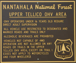
The Tellico OHV Area is a fee access area.
The cost is $10.00 per day/vehicle (as 0f 1-1-05) payable at the Forest
Service entrance station. The station is operated on the honor system,
so you will need to have correct change (they do accept checks). The
money collected here is used to keep the trails open for all of us.
Southern Four Wheel Drive Association (SFWDA) maintains the Tellico
ORV trail system and contributes thousands of dollars and man-hours
to this endeavor each year. If it weren't for their efforts in conjunction
with the Forest Service, we wouldn't have this area to enjoy with
our friends and families. Please do not litter or drive off the established
trails. This is a dry county and it is against the law to have alcoholic
beverages in your vehicle within the ORV area. If you get caught with
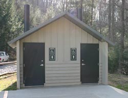
it, you will be fined, you have been warned. Bathroom facilities are
available at the parking area.
Directions: From Murphy, North Carolina
From the McDonalds in Murphy on Hwy 64, turn
north (left) onto Hiwassee St and go to the first traffic light. Turn
left at light onto Tennessee St and leave town, the road becomes Joe
Brown Hwy (there is a couple of places along here to buy gas) continue
for 2.8 miles until you come to a blinking caution light. Turn right
at caution light and continue for approx. 5.5 miles and turn right
onto Davis Creek Road. Pavement will end soon and the Forest Service
entrance station will be on your left. Trail #1 starts here and continues
through the ORV area and turns into River Road at the NC/TN state
line.
Closest town: Murphy North Carolina
For more information:
Southern Four Wheel Drive Association
District Ranger, USDA Forest Service,
Murphy, North Carolina
704-837-5152
Forest Supervisor,
National Forests in North Carolina,
704-257-4200
History:
The Upper Tellico Area has mainly been owned
by private timber companies, who between 1950 and 1969 extensively
logged the area. Many roads and skid trails were built to accomplish
the logging. As these roads were abandoned, nature restored some of
them to nearly the original condition of the land. Other roads were
discovered by ORV enthusiasts. Unfortunately, many of these routes
had been poorly located – with steep grades and no drainage.
They became deeply rutted and eroded as a result of the ORV use.
The Forest Service purchased the Upper Tellico
Area in 1980, and began a program of restoration. OHV opportunities
will remain available, but will be designated to be compatible with
the environment.
Elevation Change: 2500' to 4979
Rating:MOST DIFFICULT Trail
(1) EASIEST to (10)
Rain or snow can increase the ratings by two to three points.
1-3 : trails with obstacles that are easy to
navigate. In good weather these trails may not require the continual
use of four-wheel drive (4WD).
4-7 trails that are more demanding and require
4WD. A wide variety of challenges, including stream crossings, mud
holes, and boulders.
8-9 Trails with deep mud holes and laborious
rock climbing . There is a chance for parts breakage and body damage
on these trails.
10 Trail with the most difficult obstacles.
Rollovers, breakage and body damage is to be expected here.
These trails were shut down in 2009 by the NC Forestry Service so the information below no longer applies however it is good info on the trails so i have kept it here for refernce.I will do what i can to keep the openings of trails up to date for you.
here is the lastest: Left Loop of Tsali Trail System Reopened
Date(s): Feb 28, 2014
Robbinsville, N.C., Feb. 28, 2014– The Left Loop of the Tsali Trail system has reopened. Last month, the U.S. Forest Service closed the trail because of a slide along the trail. Located near Fontana Lake, Tsali Recreation Area is nationally known for its 42-mile trail system. The four-loop network is open to hikers and horses, but the system is best known as a challenging mountain bike course.
The Upper Tellico OHV Area is famous for some
of the best 4x4 trail riding in all of America. It has something to
challenge off-roaders of all experience levels. Trail names like Guardrail,
Helicopter Pad, Slick Rock and School Bus all conjure up visions of
adventurous steep hills and adrenaline pumping fun. The Upper Tellico
Off-Road Vehicle Area is near the western end of North Carolina at
Allan Gap (2850 feet elevation) just south of the Tennessee border
in the Natahala National Forest
. The closest town south is Murphy,
North Carolina | n Cherokee County. On the northwest end of this
area is Tellico Plains Tennessee.
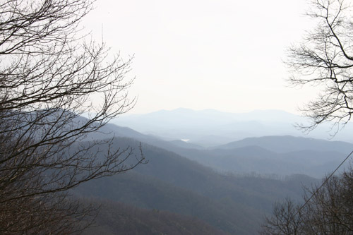
This high-elevation basin is formed by the
Unicoi Mountains. Amid the high oaks and 8000 acres of rugged, steep
terrain. lies the source of the Tellico River and its numerous feeder
streams. The ORV area's vary in elevation from 2,500 feet on the Tellico
River at the North Carolina-Tennessee border to nearly 4979 feet on
Grassy Top Mountain. Eleven 4WD trails ranging from EASIEST to MOST
DIFFICULT are clearly marked. Near stock Jeeps, SUVs and all-terrain
four wheelers can have a great time on the easy to moderate trails.
The harder stuff is usually pretty tough and it's quite common to
see huge tires, custom stretched frames and high horsepower vehicles
on these trails.
Tellico may offer something for everyone but most of the Tellico trails
are challenging. As stated before there are plenty of less threatening
trails in Tellico - many suitable for stock . But because of the inherent
difficulty of most of the trails, front and rear tow hooks are a necessity.
The Pros recommend 33" mud tires (or larger), a suspension lift,
a locker or two, a winch and tow straps for many of the trail rides.
These items are required for the harder rides. Spare parts (tires,
axles, drive shafts, U-joints, etc.) are recommended for the hardest
trails.
Pack your lunch for a meal on
the trail. Absolutely no alcohol allowed on the
trails. Everyone must wear seat belts at all times. Most of all
be safe, be smart and always watch out for the other guy.
Tellico Ride Appalachian Off-Road Club
Great Smokey Mountain Trail Ride(GSMTR) Southeast Landcruiser Association